By Peter Jackson, Local Journalism Initiative Reporter, The Telegram
September 1, 2023
The first major storm of the season is expected to brush by the island of Newfoundland this week, but it’s not likley to bring the kind of devastation witnessed last year in Port aux Basques and much of the Maritimes.
Hurricane Franklin is expected to head northeast through Tuesday and into Wednesday, and by early Friday it’s forecast the centre will be southeast of the Avalon Peninsula.
“There has been some uncertainty relating to how close the centre will track in relation to Newfoundland, but at this point in time it’s expected the centre will remain offshore, in turn keeping the most severe impacts offshore,” SaltWire Network weather specialist Allistair Aalders told The Telegram.
Flooding is still a major risk, he added.
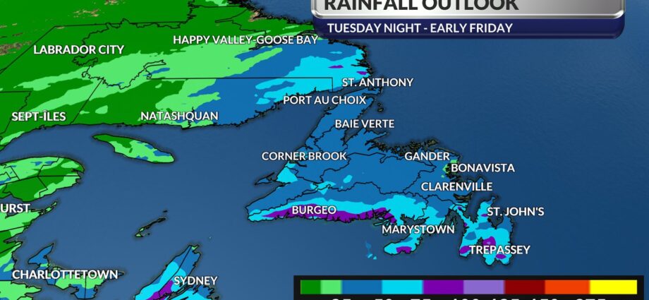
“Moisture from Franklin will feed into a non-tropical area of low-pressure that will move across Atlantic Canada mid-week. For Newfoundland and Labrador, this means we can expect rain at times heavy along the south coast beginning in the morning into the afternoon, and will spread northward across the island portion of the province and into southeastern Labrador Wednesday afternoon and night.”
The rain will continue throughout Thursday and will fall heavy at times with a risk of thunderstorms.
“It’s expected that late Thursday into Friday the rain will ease to lighter and more scattered showers,” Aalders said.
Total rainfall is difficult to predict, he said, but it’s likely to average 20-40 millimetres across the island and southwest Labrador, with possible local amounts as high as 100 mm.
Wind gusts will peak at 40 to 80 km/h.
Legacy of destruction
In coastal towns like St. Vincent’s-St. Stephen’s-Peter’s River, however, they aren’t taking any chances.
“I really hope and pray we don’t get pounded again this year,” Mayor Verna Hayward said Monday.
The town on the southeast tip of the Avalon Peninsula was hit hard by hurricane Larry two years ago, when a storm surge washed away wharfs and took out a section of road connecting St. Vincent’s and St. Stephen’s.
Residents of one community had to drive a 250-kilometre loop around the peninsula just to pick up mail.
Hayward said last year’s post-tropical storm Fiona caused more headaches when it took out some infrastructure near the beach — a popular tourist destination — and again washed away the shoulder of the road.
Even though it’s only August, maintenance staff have already removed all signage and benches from the shoreline.
Fiona dealt its worst blow to Port aux Basques on the southwest tip of the island, where 100 homes and other structures were either wiped out or irreparably damaged. One woman lost her life.
That storm was also the most costly weather event to ever hit Nova Scotia and P.E.I., according to the insurance bureau of Canada.
The misery didn’t end there for Nova Scotia. Just last month, flash floods caused by 250 millimetres of rain in just 24 hours damaged homes, businesses, roads, rail lines and bridges, and contributed to the deaths of four people, including two six-year-old children.
Record temps
Climatologists attribute the increasing intensity of storms in the region to human-caused global warming, and the risks are augmented this year by the added effect of El Nino, a natural warming cycle that occurs every two to seven years.
The combination of the two phenomena has helped set record-high temperatures across the Atlantic Ocean since March.
Water temperature is a key factor in determining the size and intensity of hurricanes.
Last week, Public Safety Minister John Hogan stressed the importance of being prepared for storms.
He said people should make sure they have:
• an emergency kit;
• gas in their vehicles;
• enough food and water to last several days;
• adequate home insurance;
• loose items and debris on property cleaned up or secured; and
• important documents in a bag.
Peter Jackson covers Indigenous and rural affairs for The Telegram.
Subscribe to our newsletter.


